
Learner Outcomes:
 This course discusses the practical methods to digitally document, model, store, and share required spatial and temporal information throughout the construction project’s lifecycle. Learners will get familiarized with the different state-of-the-art remote sensing technologies applicable to automating the collection and analysis of field construction information. The learners will be able to use technologies, such as laser scanners, to automate construction engineering and management processes, including, progress monitoring, quality control, structural integrity assessment, and safety management. Learners will be provided with the practical strategies and tools necessary to analyze the acquired field information to promote the seamless transfer of information between the real and digital worlds. These technologies and methodologies will allow the students to apply the domain of Field Information Modeling (FIM) in practical settings.
Introduction to Field Information Modeling (FIM):
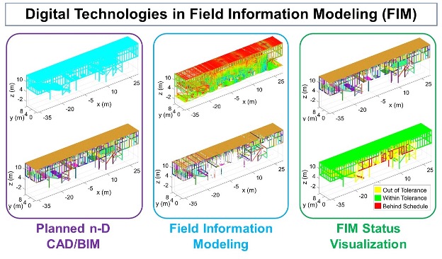
Fundamental project management and control principles, including the Deming cycle and lean project delivery, warrant fast, frequent, and reliable field data collection and analysis to foster continual improvement. In the context of schedule and cost control, for instance, daily measurement of percentage planned complete, recommended as part of the Last Planner® system, combined with frequent earned value analysis, requires up-to-date knowledge of the progress of activities. In the case of construction quality control, construction rework, when left unnoticed, can span up to 25% of the total contracted construction cost, create significant delays (Berlin Airport), or much worse cause structural instabilities (Eindhoven Airport) and possibly fatalities (Neurath power station scaffolding). Reliable, and frequent collection and analysis of relevant field data are, hence, necessary to reduce the adverse effects of rework in construction.As the amount and frequency of field data increases, the existence of a robust process for continuous collection, analysis, modeling, and management of the data becomes even more instrumental. The automation of the latter process is particularly important since field data collection and analysis are frequently required, repetitive tasks and generally not considered tool time (productive time). This leads to the conception of an essential process to support project information modeling during construction, referred to as Field Information Modeling (FIM): the process of transforming field data into intelligent, tangible, and semantic digital data as a means of enabling the seamless flow of information between the field and the digital world.