
During construction, the designed BIM serves as a detailed project baseline to aid field construction work. Once constructed, relevant field data must be collected, converted into semantic digital information, and consequentially compared to the designed BIM to ensure compliance. Any incompatibility between the plan and the field must be immediately recognized to enable project proponents to take corrective measures on time. The latter process of collecting and transforming field data into intelligent, tangible, and semantic digital information for comparison with the designed BIM is referred to as Field Information Modelling (FIM)™.
As one of the means of acquiring field data, point clouds provide a unique opportunity to discretize the surrounding surfaces in to 3-dimensional (3D) coordinates (with intensity and/or colour information). These point clouds can be utilized for progress monitoring, quality control, digital twining, and health monitoring. Frequent manual processing of the point cloud data is impractical due to the time, cost, and subjectivity associated with manual analysis and modelling practices. Hence, current research focuses on automating the process of point cloud processing.
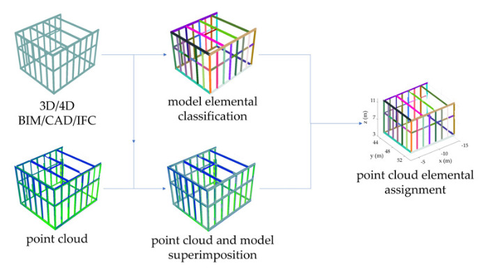 In BIM-based construction projects, the designed BIM can be utilized to determine the type and geometry of objects, which must be extracted from the registered point cloud. With the point clouds, registered to the coordinate system of the BIM, it then becomes possible to define a search space around each classified element in the BIM to detect the corresponding object from the point cloud. The process is schematically shown in the image on the left.
In the absence of construction errors, the accuracy of the point cloud analysis becomes only a function of the measurement errors along with the point cloud to model registration errors. In the presence of noticeable construction errors (which is the typical general case), the problem is more complicated, and requires more sophisticated pattern recognition, mathematical modeling, and machine learning techniques to correctly identify the correspondences. In such cases, particularly when shape considerable shearing and warping/deformation are not of concern, the process presented in Maalek (2021), can be utilized as demonstrated in the following video.